Reminds me of 9th/10th Grade Science. basic stuff to remember
Week 1:
- Consumptive Value: Consumptive value refers to the value of natural resources that are used directly and depleted by people.
- Use and Non Use Value:
- Use Value: Making use of it now. (Direct, Indirect, Option)
- Direct: wood
- Indirect: oxygen from air
- Option: Potentially use it in future.
- Non Use Value: Leave it for others or future. (Existence Value, Altruistic, Bequest)
- Existence: Satisfaction from it existing
- Altruistic: Leave it for others
- Bequest: Leave it for next generation.
- Use Value: Making use of it now. (Direct, Indirect, Option)
Week 2
- Abiotic Factors: Non living physical chemical parts of the environment. Examples: Soil, Water, Climate, Altitude
- Biotic: Living things like animal, plants.
- Climax means the end result of a forest:
- Climatic Climax: The final forest depends on Climate. warm high rainfall → Tropical Rainforest
- Edaphic: Depends on Soil. Waterlogged will lead to only specific plants growing there
- Disiclimax: Disturbance from Humans and Animals. grassy pasture maintained by heavy cattle grazing
- Catastrophic: Maintained by natural catastrophes like fire, floods or major storms. Pine Forests need heat to open the cones.
- Learning about history/general application: silvics
- Application/Science of Cultivating forest corps: silviculture.
- Characteristics of Pioneer Species:
- Extreme Tolerance
- Rapid Growth and Short Lifecycle
- High Seed Production
- A lot of Light
- Nitrogen Fixation
- Compensation Point - Consumes exactly same energy as it’s generating. photosynthesis = respiration
- Net Primary Productivity = APAR (Absorption/Fuel) x LUE (Efficiency)
- sere is the entire sequence of communities. Different types of sere:
- Xerosere: Dry and Arid region
- Lithosere: Stone
- Psammosere: Sandy
- Hydrosere: Water region. Sweet water
- Halosere: Saline water.
- Xerosere: Dry and Arid region
- Forest Mensuration: Measuring Forest. Heights of trees. Basal Area (cross-sectional area of all trees at DBH per unit of land, gives the density of trees at the forest)
Week 3
- Weathering: Process by which rocks are broken down into smaller and smaller pieces
- Physical Weathering:
- Breaking them down without changing the chemical composition
- Thermal Stress
- Cryofacturing: extreme cold
- Ocean waves
- Chemical Weathering
- Changes the chemical structure.
- Carbonation
- Oxidation
- Hydrolysis
- Biological Weathering
- Organic creatures break down the rocks by either physical processes or chemical byproducts
- Root Wedging (Physical)
- Lichen Acid (Chemical)
- Animal Burrowing. Rabbits or Earthworms move rock and expose them to the world
- Physical Weathering:
- Alluvial Soil: Formed by deposition of elements. Khadar: newly deposited by rivers. Bhangar: old soil. found at higher altitudes
- Regur/Black Cotton Soil have self ploughing characteristics.
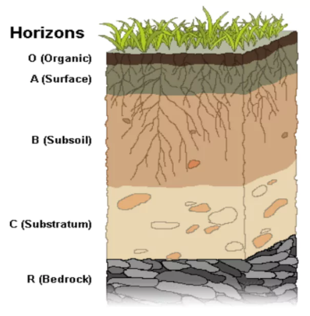
- Soil Profile:
Week 4
-
False and Absolute Form Factor:
- False Form Factor: Breast Height: 1.37 meters is taken as the base diameter
- Absolute Form Factor: Base of the Tree is taken as the base diameter
- Normal Form Factor: Base of the tree is 10% of the height
-
Important Measurements
- Stand Basal Area = Area = or
- 1 Ha = 10,000 m
- DBH - Diameter at Breast Height
-
Different type of measurement:
- Direct: Put up a measuring tape
- Indirect: Using similary triangles or trigonometry
-
Sin = Opposite/H and Cos = Adj/H.

-
Spacing Factor = Average Spacing/Average Diameter
-
Sampling
- Simple Random: Each tree has an equal and independent chance
- Systematic: Selecting every k unit starting from a random from 1 to k.
- Stratified: Divide the forest based on a shared characteristic and pick samples from each
- Example: Monoculture Teak and Climatic Climax Teal
- Multistage: Sampling is done in a “hierarchy,” moving from large groups to smaller units.
- Stage 1: Randomly select 5 large forest blocks out of 50.
- Stage 2: Within those 5 blocks, randomly select 10 sample plots.
Week 5
- Accuracy: Closer to correct value
- Precision: How close are the measured value to each other
- List of Samples is called a Frame.
- Types of LiDAR
- Topographical LiDAR: Infrared
- Bathymetric LiDAR: Green Light
- Types of Resolution:
- Temporal: Number of Flyovers/How frequently are we taking images
- Spatial: Size of a Pixel in an Image
- Spectral: Number of colors (B/W)
- Radiometric: Amount of bits/information in each band/color.
- Types of Surveying:
- Plane Surveying: Assumes Earth is Flat. Covers a smaller area
- Geodesic Surveying: Correctly assumes earth is a geode. Covers >250 kms
- Census means to measure everything
- Sampling means to only measure some.
- Types of Errors:
- Natural: variability in natural conditions.
- Instrumental: instrument has erodded or broken
- Personal: personal mistakes while using the instrument/measuring
- IMU: Inertial Measurement Unit is a chip that calculates the axis, acceleration by combination of accelerometers, gyroscopes and magnetometers.
Week 6
- HIPPO -
- H is the loss of Habitats
- I is Invasive species
- P is Pollution
- P is human over Population
- O is for Over harvesting
- Deterministic Factor: Predictable Factor that act at large population sizes
- Birth Rate
- Death Rate
- Population Structure
- Stochastic Factor: Random Factors that act at small population sizes.
- Environmental Variation
- Forest Fire
- Diseases
| Factor | Description | Example |
|---|---|---|
| Demographic Stochasticity | Random “luck” in population stats. | A small group of 5 animals where, by chance, all offspring are male, leading to extinction. |
| Environmental Variation | Fluctuations in weather or food. | A single drought killing 9 out of 10 remaining plants of a rare species. |
| Catastrophes | Sudden, high-impact events. | A forest fire or a sudden plague wiping out a localized group. |
| Genetic Processes | Issues arising from a small gene pool. | Inbreeding depression: Mating between close relatives reveals harmful recessive traits. |
| Migration | Movement of individuals. | 3 tigers leaving a forest results in 0 tigers; 10 tigers leaving a group of 50 still leaves 40. |
- I = PxAxT
- I Impact
- P Population Pressure
- A Affluence
- T Technology
- Wildlife Protection Act defines “hunting, with its grammatical variations and cognate expressions, it includes, killing or poisoning of any wild animal or captive animal and every attempt to do so.” So, if somebody is trying to attempt to kill a captive animal, or poison a wild animal, that is hunting
Week 7
-
Clear Felling:
Advantages:- Simple system
- Uniform Crop
- Mimics natural processes of fire
Disadvantages:
- Increases Soil Erosion and Landslides.
-
Different Types of Ages:
- Crop Age: Actual chronological age.
- Felling Age: Age when it’s cut down.
- Rotation Age: Pre planned duration at which it’s cut and replanted
- Maturity Age: Age at which it reaches a desired condition.
-
Taungya Regeneration:
- Artificial Regeneration with the help of villagers.
- Let villagers cultivate on a part of the land
- They’ll stand tend small sapling to help tree grow back
-
Stand Tending: includes cleaning, thinning, pruning, and weeding. It’s the “maintenance” phase of a forest’s life
-
Natural Regeneration:
- Letting the trees grow by themselves.
- Ring Weeding: Assisted Natural. Remove weeds at 1m away from the trunk
- It’s cheap
-
Artificial Regeneration
- Controlling genetics
- Direct Sowing
- Planting Seedlings
- Transplanting Trees
- Only choice for Afforestation